From
LithoX GIS
AI-powered, cloud-native GIS for exploration teams
Build maps, filters, geochemistry plots, and reproducible geoscience workflows from your Exploration Data Workspace — without wrestling with desktop GIS projects, broken layers, local files, or manual visualization setup.
Ask LithoX for the map, chart, filter, or workflow you need. LithoX turns your request into editable GIS layers, geochemistry plots, saved views, and repeatable workflows your team can inspect, modify, rerun, and export.
Traditional desktop GIS is powerful, but it was not built around geologists working with constantly changing AOIs, drillhole tables, geochemistry, assays, public datasets, contractor folders, and AI-assisted workflows.
LithoX GIS gives exploration teams a browser-based geoscience workspace where maps, plots, filters, data tables, saved workflows, and exports all live together.
- No local project files
- No broken file paths
- No stale map exports
- No rebuilding the same views every time data changes
Trusted data first
LithoX GIS starts with your Exploration Data Workspace
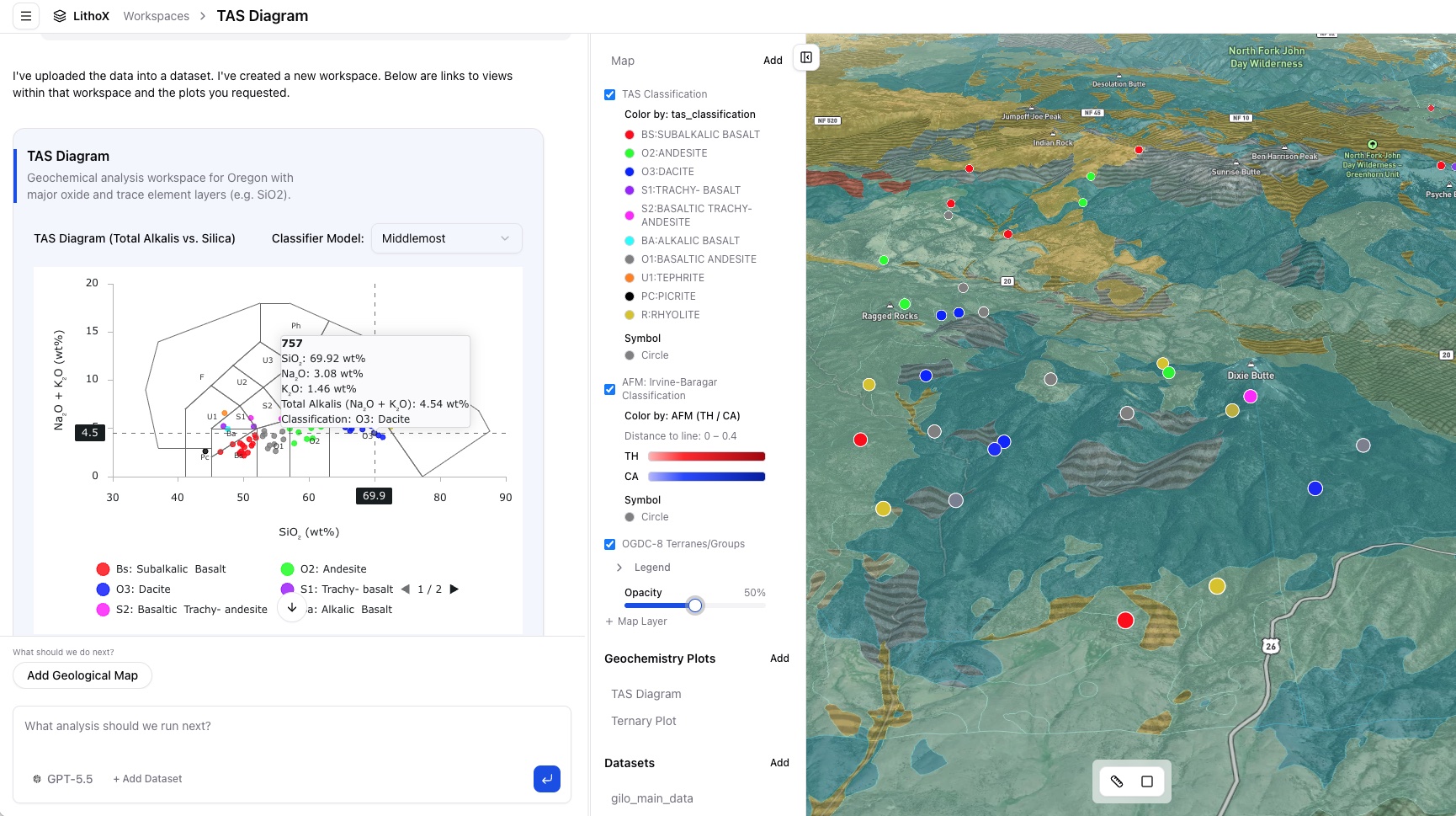
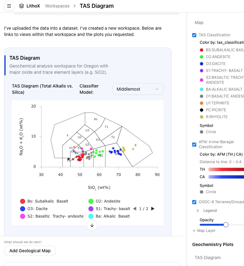
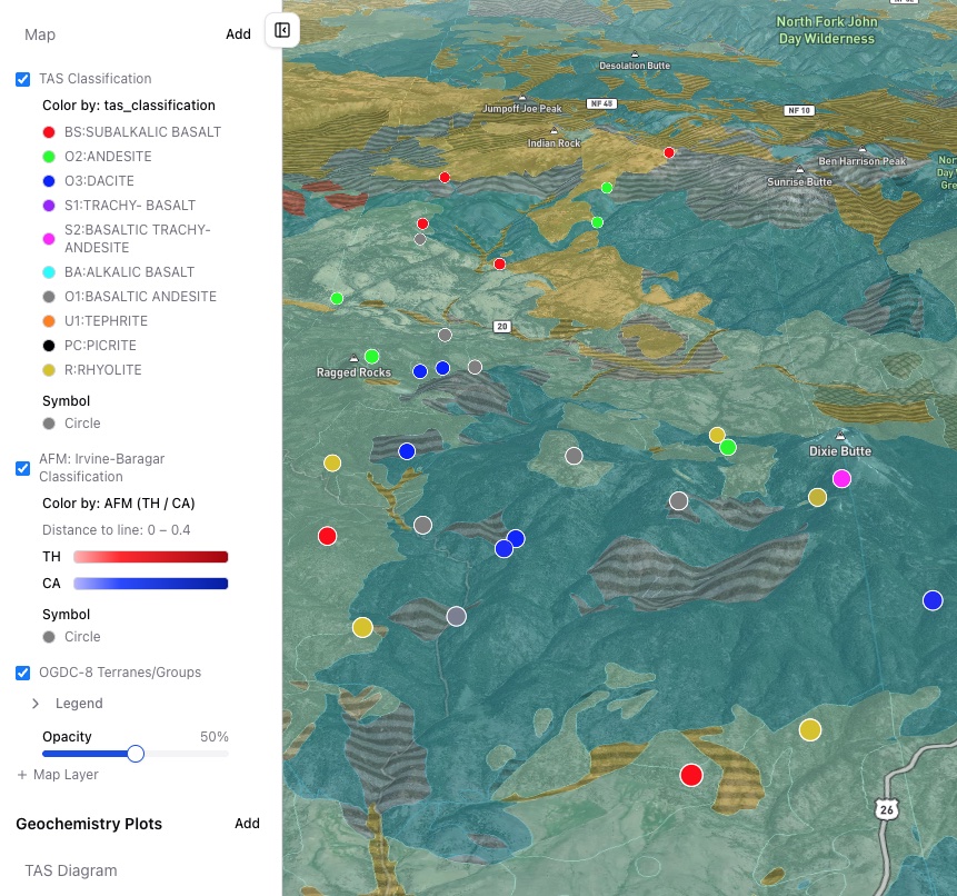
Every LithoX GIS project begins with an Exploration Data Workspace: a clean, source-tracked exploration workspace built from public datasets and private project files.
Select a claim block, district, or project area. LithoX pulls relevant public geology, geochemistry, geophysics, mineral occurrences, claims, access, and terrain data, then combines it with your private drillholes, assays, GIS layers, reports, and contractor deliverables. The Exploration Data Workspace standardizes schemas, fixes CRS and unit issues, flags QA/QC problems, and preserves provenance before analysis begins.
Once the Exploration Data Workspace is clean, LithoX GIS becomes the cloud-native analysis layer on top.
Clean exploration data below. AI-powered GIS on top.
Built on
Exploration Data Workspace
Public + private data, standardized and source-tracked before GIS analysis begins.
The GIS bottleneck
Geologists know what they want to see. GIS makes them configure it manually.
Exploration teams spend too much time setting up maps instead of interpreting geology.
A simple question can require finding the right layer, joining the right table, fixing styles, configuring filters, generating plots, and rebuilding everything when new data arrives.
Desktop GIS is powerful, but it is often file-based, fragile, and disconnected from the fast-moving exploration workflow.
To
With LithoX GIS
AI-powered GIS
Ask for the map. Inspect the logic. Edit everything.
LithoX GIS lets geologists build plots and maps in seconds so they can spend more time on analysis and less time uploading data, mapping fields, and configuring visualizations.
Ask LithoX to:
The AI accelerates setup. The geologist stays in control.
A cloud-native GIS platform where chat, maps, plots, data tables, and workflows all operate on the same Exploration Data Workspace.
From AOI to reproducible map workflow
Start from an Exploration Data Workspace
Draw or upload an area of interest. LithoX creates a clean exploration workspace with public and private data clipped, standardized, validated, and source-tracked.
"Create a workspace for this AOI with public geology, regional geochemistry, MINFILE occurrences, claims, roads, DEM, and intrusive contacts."
Output
Ask LithoX GIS for the map you need
Use chat to define the map, filters, styling, labels, and view. Everything can be inspected and edited.
"Show Cu samples above the 90th percentile, color points by Mo, size points by Au, and overlay faults and intrusive contacts."
Output
Build geochemistry plots from the same data
Create plots directly from your Exploration Data Workspace instead of moving data between GIS, spreadsheets, and specialist plotting tools.
"Create a Cu vs Mo scatter plot colored by lithology and filtered to rock samples."
Output
Use full GIS controls when you want precision
LithoX GIS is not only chat. Users can manually control layers, symbology, filters, joins, buffers, views, and exports. The AI is a workflow accelerator, not a black box.
Output
Save repeatable workflows as skills
Turn recurring analysis into reusable LithoX skills that can run again when new data is added.
Output
Export outputs into the tools your team already uses
Export maps, layers, tables, plots, and workflow outputs into the broader exploration stack.
Output
A complete cloud-native GIS workflow for geoscience teams
AI-assisted map configuration
Describe the map you want in plain English, and LithoX configures the GIS workspace from your grounded AOI data. It selects the relevant layers, applies filters, sets symbology, labels features, and creates saved views — the same things you could do manually, just faster.
Full manual GIS controls
Use standard GIS controls whenever you need precision. Adjust layers, styling, labels, filters, joins, buffers, tables, legends, and saved views directly.
Grounded geochemistry plots
Create scatter plots, histograms, element comparisons, correlation views, and custom charts from standardized AOI geochemistry and assay data. LithoX plots your data; it does not invent interpretations.
Map-linked plots
Select samples in a plot and see them on the map. Filter the map and update the plot in the same workspace.
Reusable GIS workflows
Save repeated map, filter, and geochemistry workflows as LithoX skills that can run again when new data is added.
Cloud-native collaboration
Keep maps, data, plots, filters, provenance, and outputs in a shared browser-based workspace instead of local desktop project files.
Source-tracked layers
Every map layer is tied back to the Exploration Data Workspace, with source, vintage, CRS, transformations, QA/QC status, and review history.
Exportable outputs
Export data, map layers, plots, figures, and saved workflow outputs into the tools your team already uses.
Replace repetitive GIS setup, not geological judgment
Replaces repetitive work like
Does not replace
Built for how exploration teams actually work
Exploration projects change constantly. New assays arrive. Public datasets update. Contractors send revised files. Geologists need to compare AOIs, rerun filters, share maps, and export outputs without rebuilding local GIS projects.
LithoX GIS is cloud-native by default, so your workspace can stay connected to:
The map is no longer a static project file. It becomes a living, versioned exploration workspace with a full audit log.
Outputs your team can review, share, and export
Ready to work with your AOI data through LithoX GIS?
Start with an Exploration Data Workspace, then ask LithoX GIS to generate the maps, filters, plots, and workflows your team needs.